|
Terra Flight Aerial Imaging has provided UAV or drone aerial imagery services since 2015 as a fast and affordable approach for acquiring aerial data. Terra Flight Aerial Imaging does not provide UAV services to the residential real estate market.
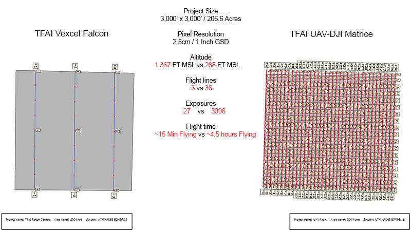
Terra Flight has employees that have been in the aerial surveying business for decades and we fully understand all the technical aspects of the aerial surveying industry as well as the limitations of UAV acquired imagery. Manned Aerial Survey Aircraft vs. Unmanned Aerial Vehicle (UAV) Using a low altitude capable UAV allows a unique perspective that is not attainable with a manned aerial survey aircraft. Some projects can be flown utilizing our UAV more competitively priced and efficiently than deploying our manned aerial survey aircraft. However, we generally limit the size of any project to a maximum size of approximately 200 acres and will not use a UAV on complex sites. Referring to the 200-acre graphic example below, our UltraCam Vexcel Falcon aerial sensor only requires 27 images to acquire this site at a pixel resolution of 2.5 CM or 1-inch GSD. To obtain this same site at the identical pixel resolution, a total of 3,096 images is required using our DJI Matrice UAV. |
|
The number of images required for the site illustrated above, will vary by use of different UAV sensors. The number of images also depends the overlap configurations used. In the example above we used heavy overlap both with forward and side, in order to achieve higher image quality and accuracy results. If the 200-acre site is relatively flat and unimproved, the UAV and the Falcon sensor both perform well in producing both acceptable quality and accurate digital ortho images. Let Terra Flight Aerial Imaging provide your next aerial imagery project by use of the proper technology and aerial data processing. |